Mongabay.com is considered a leading source of information on tropical forests by some of the world's top ecologists and conservationists. BIOME CHARTS

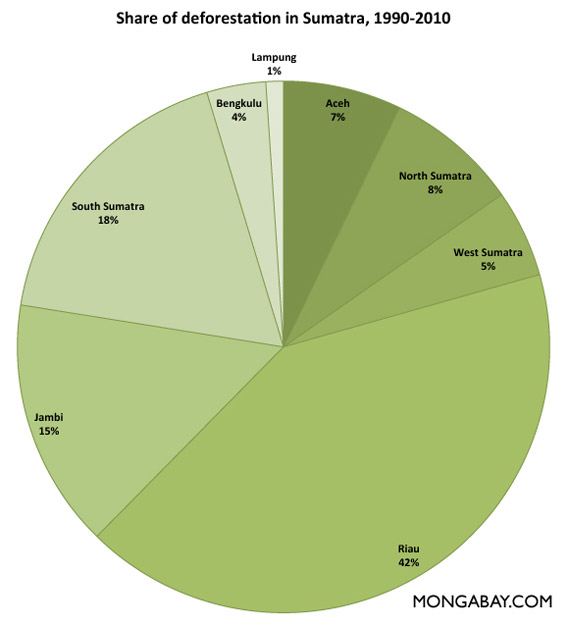
CHART: share of deforestation in Sumatra


Chart: share of deforestation in Sumatra
Click image to enlarge


This forest cover data is from Margono et al 2012. Related story at Rainforests decline sharply in Sumatra, but rate of deforestation slows.

Share of deforestation in Sumatra by province, 1990-2010 (square kilometers)


1990
2000
2010
Total
Degraded
Primary
Total
Degraded
Primary
Total
Degraded
Primary
Aceh 3.861.782.083.431.811.623.321.791.53
North Sumatra2.532.120.412.121.760.351.921.690.24
West Sumatra2.691.960.732.41.730.672.291.70.59
Riau 5.674.181.493.83.490.322.532.290.23
Jambi 2.651.940.711.821.40.411.511.110.4
South Sumatra2.281.970.310.990.710.280.940.670.27
Bengkulu 1.040.470.570.810.340.460.770.320.45
Lampung 0.390.310.090.320.230.090.310.230.08
Total 21.1114.736.3915.6911.484.2113.589.793.79


CITATION: Belinda Arunarwati Margono, Svetlana Turubanova, Ilona Zhuravleva, Peter Potapov, Alexandra Tyukavina, Alessandro Baccini, Scott Goetz and Matthew C Hansen. Mapping and monitoring deforestation and forest degradation in Sumatra (Indonesia) using Landsat time series data sets from 1990 to 2010. Environ. Res. Lett. 7 034010 doi:10.1088/1748-9326/7/3/034010 Published 19 July 2012


Other sections

LATIN AMERCA ASIA GLOBAL MORE DEFORESTATION DATA


what's new | rainforests home | for kids | help | madagascar | search | about | languages | contact

Copyright Rhett Butler 1994-2015

Carbon dioxide (CO2) emissions generated from mongabay.com operations (server, data transfer, travel) are mitigated through an association with Anthrotect,
an organization working with Afro-indigenous and Embera communities to protect forests in Colombia's Darien region.
Anthrotect is protecting the habitat of mongabay's mascot: the scale-crested pygmy tyrant.

"Rainforest" is used interchangeably with "rain forest" on this site. "Jungle" is generally not used.