Calculating Deforestation Figures for the Amazon
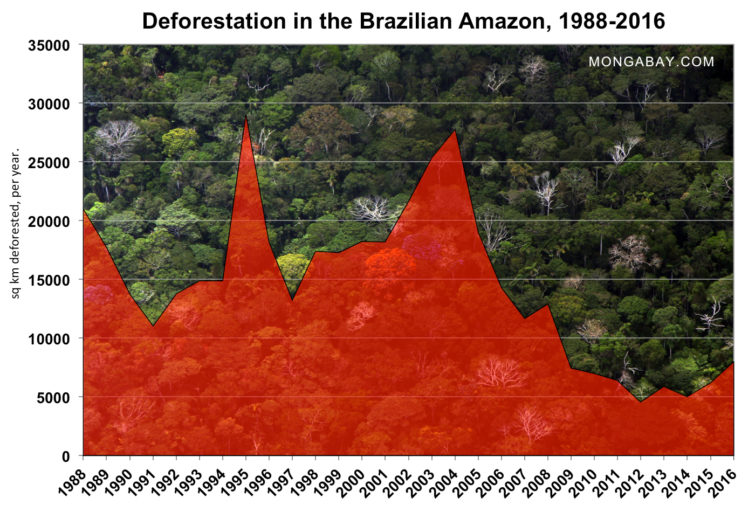
These figures are calculated from estimates provided by the Brazilian National Institute of Space Research (INPE) and the United Nations Food and Agriculture Organization (FAO). The figures only refer to the Brazilian Amazon, which accounts for roughly 60 percent of the Amazon rainforest.
According to a study released in September 2009 by Brazil's National Institute for Space Research (INPE), at least 20 percent land deforested in the Brazilian Amazon is regrowing forest.
Please note: Amazon deforestation data is updated several times a year here.
| Period | Estimated Remaining Forest Cover in the Brazilian Amazon (sq. km) | Annual forest loss (sq. km) | Percent of 1970 cover remaining | Total forest loss since 1970 (sq. km) |
| pre-1970 | 4,100,000 | |||
| 1970 | 4,001,600 | 97.6% | 98,400 | |
| 1977 | 3,955,870 | 21,130 | 96.5% | 144,130 |
| 1978-1987 | 3,744,570 | 21,130 | 91.3% | 355,430 |
| 1988 | 3,723,520 | 21,050 | 90.8% | 376,480 |
| 1989 | 3,705,750 | 17,770 | 90.4% | 394,250 |
| 1990 | 3,692,020 | 13,730 | 90.0% | 407,980 |
| 1991 | 3,680,990 | 11,030 | 89.8% | 419,010 |
| 1992 | 3,667,204 | 13,786 | 89.4% | 432,796 |
| 1993 | 3,652,308 | 14,896 | 89.1% | 447,692 |
| 1994 | 3,637,412 | 14,896 | 88.7% | 462,588 |
| 1995 | 3,608,353 | 29,059 | 88.0% | 491,647 |
| 1996 | 3,590,192 | 18,161 | 87.6% | 509,808 |
| 1997 | 3,576,965 | 13,227 | 87.2% | 523,035 |
| 1998 | 3,559,582 | 17,383 | 86.8% | 540,418 |
| 1999 | 3,542,323 | 17,259 | 86.4% | 557,677 |
| 2000 | 3,524,097 | 18,226 | 86.0% | 575,903 |
| 2001 | 3,505,932 | 18,165 | 85.5% | 594,068 |
| 2002 | 3,484,281 | 21,651 | 85.0% | 615,719 |
| 2003 | 3,458,885 | 25,396 | 84.4% | 641,115 |
| 2004 | 3,431,113 | 27,772 | 83.7% | 668,887 |
| 2005 | 3,412,099 | 19,014 | 83.2% | 687,901 |
| 2006 | 3,397,814 | 14,285 | 82.9% | 702,186 |
| 2007 | 3,386,163 | 11,651 | 82.6% | 713,837 |
| 2008 | 3,373,252 | 12,911 | 82.3% | 726,748 |
| 2009 | 3,365,788 | 7,464 | 82.1% | 734,212 |
| 2010 | 3,358,788 | 7,000 | 81.9% | 741,212 |
| 2011 | 3,352,370 | 6,418 | 81.8% | 747,630 |
| 2012 | 3,347,799 | 4,571 | 81.7% | 752,201 |
| 2013 | 3,341,908 | 5,891 | 81.5% | 758,092 |
| 2014 | 3,336,896 | 5,012 | 81.4% | 763,104 |
| 2015 | 3,330,689 | 6,207 | 81.2% | 769,311 |
| 2016 | 3,322,796 | 7,893 | 81.0% | 777,204 |
| 2017 | 3,315,849 | 6,947 | 80.9% | 784,151 |
| 2018 | 3,307,949 | 7,900 | 80.7% | 792,051 |
Recent news on deforestation in the Amazon
- Brazil: deforestation in the Amazon increased 29% over last year [11/30/2016]
- Brazil revises Amazon deforestation 6% upward [10/04/2016]
- Amazon deforestation jumps in Brazil, but remains historically low [11/27/2015]
- Deforestation declines in the Amazon rainforest [10/06/2015]
- Amazon paradox: drop in large-scale deforestation makes enforcement more difficult [08/19/2015]
- What’s the current deforestation rate in the Amazon rainforest? [05/15/2015]
- Platform provides near-real time analysis of deforestation in non-Brazilian Amazon [04/09/2015]
All figures derived from official National Institute of Space Research (INPE) data. Individual state figures.
For the 1978-1988 period the figures represent the average annual rates of deforestation.

Accumulated forest loss in the Amazon. Click image to enlarge.

Brazil could substantially boost its agricultural output while increasing protection of its native ecosystems, finds a new analysis published by the Climate Policy Initiative (CPI), an international think tank. The study, titled Production and Protection: A First Look at Key Challenges in Brazil, analyzes agricultural productivity, trends in land use, and policies governing rural lands in Brazil. It concludes there is "ample scope for enhanced protection of natural resources and growth of agricultural production in Brazil."



(Left) This figure shows the change (in millimeters per day) in daily average precipitation after total Amazon deforestation compared to before deforestation. The pink to dark-pink range indicates a drop in precipitation of up 1.6 mm less per day once the Amazon is gone. Areas with statistically significant changes are hatched. (Right) The researchers' model indicated that the surface temperature in the Amazon region would increase by up to 2 degrees Celsius (darkest green) over a 14-year period following deforestation. The region of Amazon deforestation is boxed. Caption courtesy of Princeton University.

LEFT: (A) Confirmed and suspected deforestation caused directly by gold mining in the southern Madre de Dios region from 1999 to 2012. (B) Contribution of the three large mines compared with small mines from 1999 to 2012. Courtesy of Asner et al 2013. RIGHT: Gold mining in the Peruvian Amazon. Photo by Rhett A. Butler


The Brazilian Cattle Herd: Amazon and non-Amazon. Courtesy of Walker et al 2013


Charts and graphs for the Amazon forest
| FOREST LOSS | |
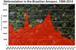 [ large medium small ] | Deforestation in the Brazilian Amazon, 1988-present 60-70 percent of deforestation in the Amazon results from cattle ranches while the rest mostly results from small-scale subsistence agriculture. Despite the widespread press attention, large-scale farming (i.e. soybeans) currently contributes relatively little to total deforestation in the Amazon. Most soybean cultivation takes place outside the rainforest in the neighboring cerrado grassland ecosystem and in areas that have already been cleared. Logging results in forest degradation but rarely direct deforestation. However, studies have showed a close correlation between logging and future clearing for settlement and farming. context of image |
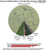 [ large medium small ] | Causes of deforestation in the Brazilian Amazon, 2000-2005 The above pie chart showing deforestation in the Amazon by cause is based on the median figures for estimate ranges. Please note the low estimate for large-scale agriculture. Between 2000-2005 soybean cultivation resulted in a small overall percentage of direct deforestation. Nevertheless the role of soy is quite significant in the Amazon. As explained by Dr. Philip Fearnside, "Soybean farms cause some forest clearing directly. But they have a much greater impact on deforestation by consuming cleared land, savanna, and transitional forests, thereby pushing ranchers and slash-and-burn farmers ever deeper into the forest frontier. Soybean farming also provides a key economic and political impetus for new highways and infrastructure projects, which accelerate deforestation by other actors." context of image |
[ large medium ] | Deforestation in Amazônia Legal State, Brazil, 1988-2005 Deforestation in Amazônia Legal State, Brazil, 1988-2005 measured stated-by-state by percent share of total forest loss context of image |
[ large medium ] | Deforestation in Amazônia Legal State, Brazil, 1988-2005 Deforestation in Amazônia Legal State, Brazil, 1988-2005 State-by-state contribution to total forest loss context of image |
[ large medium ] | Deforestation in Acre State, Brazil, 1988-2005 context of image |
[ large medium ] | Deforestation in Amapá State, Brazil, 1988-2005 context of image |
[ large medium ] | Deforestation in Amazonas State, Brazil, 1988-2005 context of image |
[ large medium ] | Deforestation in Maranhão State, Brazil, 1988-2005 context of image |
[ large medium ] | Deforestation in Mato Grosso State, Brazil, 1988-2005 context of image |
[ large medium ] | Deforestation in Pará State, Brazil, 1988-2005 context of image |
[ large medium ] | Deforestation in Rondônia State, Brazil, 1988-2005 context of image |
[ large medium ] | Deforestation in Roraima State, Brazil, 1988-2005 context of image |
[ large medium ] | Deforestation in Tocantins State, Brazil, 1988-2005 context of image |
| FOREST COVER | |
 [ large medium small ] | Amazon biomass distribution, by vegetation type The biomass range (metric tons per hectare) for general vegetation types in the Amazon Basin. The authors report the following distribution of vegetation category for the basin: Old growth terra firme forest (62.3% of the legal Amazon [(8 235 430 sq km]); Floodplain and inundated forest (4.19%); Secondary forest (1.67%); Woodland savanna (24.47%); and Grass/shrub savanna (4.79%). The authors report average biomass ranges as follows: Dense forest 272.5 Mt/ha, Open forest 200.2 Mt/ha, Bamboo forest 212.3 Mt/ha, Liana/dry forest 189.7 Mt/ha, Seasonal/deciduous forest 225.6 Mt/ha, and Varzea flooded forest 248.3 Mt/ha. Image produced by Rhett A. Butler using data from the authors. context of image |
| AGRICULTURE | |
[ medium ] | Soy expansion in the Brazilian Amazon, 1990-2005 Total deforestation and area of soybean cultivation across states in the Brazilian Amazon. Overall soybean cultivation makes up only a small portion of deforestation, though its role is accelerating. Further, soybean expansion and the associated infrastructure development and farmer displacement is driving deforestation by other actors. Note: some soybean farms are established on already degraded rainforest lands and neighboring cerrado ecosystems. Therefore it would be inappropriate to assume the area of soybean planting represents its actual role in deforestation. context of image |
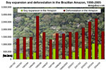 [ medium small ] | Soy expansion and deforestation in the Brazilian Amazon, 1990-2005 Annual deforestation rates and annual soy expansion for states in the Brazilian Amazon 1990-2005. Note that the 1995-1996 and 1998-1999 years were negative and do not show up on the chart. Graphs based on Brazilian government data. context of image |
 [ large medium small ] | Projected soybean exports for the U.S. and Brazil, 2004-2015 context of image |
[ large medium ] | Cattle production in Brazil, 1977-2007 |
[ large medium ] | Production and total supply of cattle in Brazil, 1960-2007 |
[ large medium ] | Soybean oil crush in Brazil, 1981-2006 context of image |
[ large medium ] | Sugar cane production & export for Brazil, 1960-2006 context of image |
[ large medium ] | World soybean production, 1980-2003 context of image |
[ large medium ] | Soy and corn acreage planted and projected in the United States context of image |
[ large medium ] | Soy and corn acreage planted and projected in the United States context of image |
[ large medium ] | Forecast world soy trade market share for the U.S. and Brazil, 2004-2016 context of image |
[ medium ] | World soybean exports, 1990-2015 context of image |
Deforestation images
Pictures of deforestation
 Expansion of cattle pasture in the Brazilian Amazon, 1998-2003. Courtesy of IPAM |
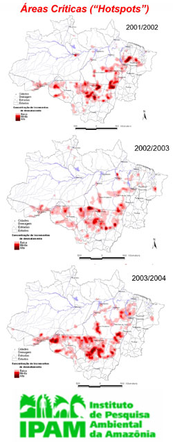 Deforestation hotspots in the Brazilian Amazon, 2001-2004. Courtesy of IPAM |


